Search This Blog

Saturday, 31 August 2013

This view from NASA's Solar TErrestrial RElations Observatory satellite will aid scientists' ability to understand solar physics to improve space weather forecasting.
Add image to your album
Email this page Post this page to your Facebook wall Tweet this page
Right Limb of the South Pole of the Sun, March 18, 2007
Click here for left eye view of PIA09326Click here for right eye view of PIA09326
Figure 1: Left eye view of a stereo pair
Click on the image for full resolution TIFF
Figure 2: Right eye view of a stereo pair
Click on the image for full resolution TIFF
Figure 1: This image was taken by the SECCHI Extreme UltraViolet Imager (EUVI) mounted on the STEREO-B spacecraft. STEREO-B is located behind the Earth, and follows the Earth in orbit around the Sun. This location enables us to view the Sun from the position of a virtual left eye in space.Figure 2: This image was taken by the SECCHI Extreme UltraViolet Imager (EUVI) mounted on the STEREO-A spacecraft. STEREO-A is located ahead of the Earth, and leads the Earth in orbit around the Sun, This location enables us to view the Sun from the position of a virtual right eye in space.
NASA's Solar TErrestrial RElations Observatory (STEREO) satellites have provided the first three-dimensional images of the Sun. For the first time, scientists will be able to see structures in the Sun's atmosphere in three dimensions. The new view will greatly aid scientists' ability to understand solar physics and thereby improve space weather forecasting.
The EUVI imager is sensitive to wavelengths of light in the extreme ultraviolet portion of the spectrum. EUVI bands at wavelengths of 304, 171 and 195 Angstroms have been mapped to the red blue and green visible portion of the spectrum; and processed to emphasize the temperature difference of the solar material. A prominence is clearly visible.
STEREO, a two-year mission, launched October 2006, will provide a unique and revolutionary view of the Sun-Earth System. The two nearly identical observatories -- one ahead of Earth in its orbit, the other trailing behind -- will trace the flow of energy and matter from the Sun to Earth. They will reveal the 3D structure of coronal mass ejections; violent eruptions of matter from the sun that can disrupt satellites and power grids, and help us understand why they happen. STEREO will become a key addition to the fleet of space weather detection satellites by providing more accurate alerts for the arrival time of Earth-directed solar ejections with its unique side-viewing perspective.
STEREO is the third mission in NASA's Solar Terrestrial Probes program within NASA's Science Mission Directorate, Washington. The Goddard Science and Exploration Directorate manages the mission, instruments, and science center. The Johns Hopkins University Applied Physics Laboratory, Laurel, Md., designed and built the spacecraft and is responsible for mission operations. The imaging and particle detecting instruments were designed and built by scientific institutions in the U.S., UK, France, Germany, Belgium, Netherlands, and Switzerland. JPL is a division of the California Institute of Technology in Pasadena.
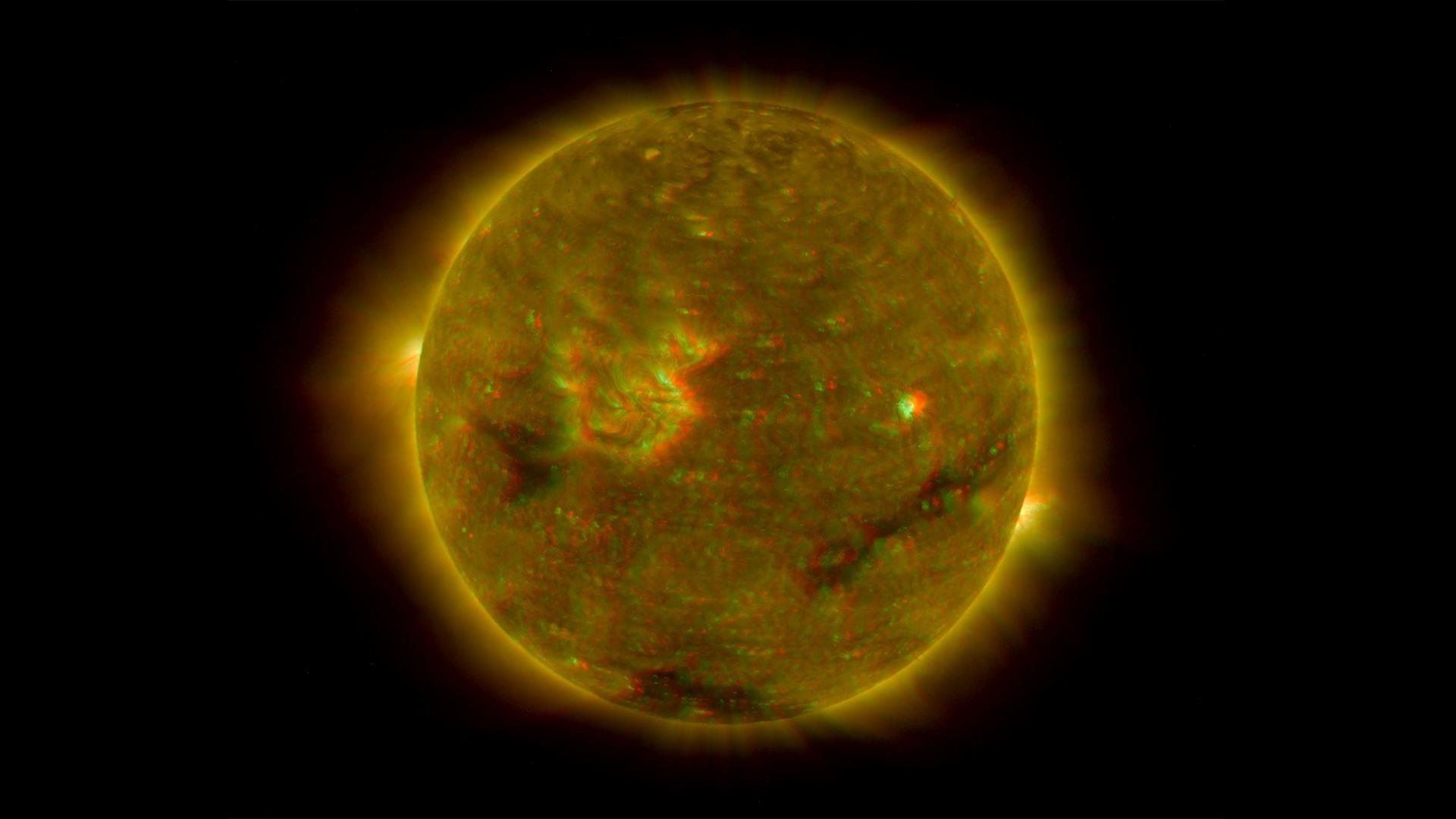
NASA's Solar TErrestrial RElations Observatory (STEREO) satellites have provided the first three-dimensional images of the Sun. The structure of the corona shows well in this image.
Add image to your album
Email this page Post this page to your Facebook wall Tweet this page
Full Disk Image of the Sun, March 26, 2007 (Anaglyph)
Click here for left eye view of PIA09321    Click here for right eye view of PIA09321
Figure 1: Left eye view of a stereo pair
Click on the image for full resolution TIFF
    Figure 2: Right eye view of a stereo pair
Click on the image for full resolution TIFF
Figure 1: This image was taken by the SECCHI Extreme UltraViolet Imager (EUVI) mounted on the STEREO-B spacecraft. STEREO-B is located behind the Earth, and follows the Earth in orbit around the Sun. This location enables us to view the Sun from the position of a virtual left eye in space.Figure 2: This image was taken by the SECCHI Extreme UltraViolet Imager (EUVI) mounted on the STEREO-A spacecraft. STEREO-A is located ahead of the Earth, and leads the Earth in orbit around the Sun, This location enables us to view the Sun from the position of a virtual right eye in space.
NASA's Solar TErrestrial RElations Observatory (STEREO) satellites have provided the first three-dimensional images of the Sun. For the first time, scientists will be able to see structures in the Sun's atmosphere in three dimensions. The new view will greatly aid scientists' ability to understand solar physics and thereby improve space weather forecasting.
This image is a composite of left and right eye color image pairs taken by the SECCHI Extreme UltraViolet Imager (EUVI) mounted on the STEREO-B and STEREO-A spacecraft. STEREO-B is located behind the Earth, and follows the Earth in orbit around the Sun, This location enables us to view the Sun from the position of a virtual left eye in space. STEREO-A is located ahead of the Earth, and leads the Earth in orbit around the Sun, This location enables us to view the Sun from the position of a virtual right eye in space. The structure of the corona shows well in this image.
The EUVI imager is sensitive to wavelengths of light in the extreme ultraviolet portion of the spectrum. EUVI bands at wavelengths of 304, 171 and 195 Angstroms have been mapped to the red blue and green visible portion of the spectrum; and processed to emphasize the three-dimensional structure of the solar material.
STEREO, a two-year mission, launched October 2006, will provide a unique and revolutionary view of the Sun-Earth System. The two nearly identical observatories -- one ahead of Earth in its orbit, the other trailing behind -- will trace the flow of energy and matter from the Sun to Earth. They will reveal the 3D structure of coronal mass ejections; violent eruptions of matter from the sun that can disrupt satellites and power grids, and help us understand why they happen. STEREO will become a key addition to the fleet of space weather detection satellites by providing more accurate alerts for the arrival time of Earth-directed solar ejections with its unique side-viewing perspective.
STEREO is the third mission in NASA's Solar Terrestrial Probes program within NASA's Science Mission Directorate, Washington. The Goddard Science and Exploration Directorate manages the mission, instruments, and science center. The Johns Hopkins University Applied Physics Laboratory, Laurel, Md., designed and built the spacecraft and is responsible for mission operations. The imaging and particle detecting instruments were designed and built by scientific institutions in the U.S., UK, France, Germany, Belgium, Netherlands, and Switzerland. JPL is a division of the California Institute of Technology in Pasadena.
IRIS Launch Set for Thursday

IRIS Launch Set for Thursday

Technicians and engineers at Vandenberg Air Force Base in California mate the Pegasus XL rocket with the Interface Region Imaging Spectrograph, or IRIS, solar observatory to the Orbital Sciences L-1011 carrier aircraft. The launch of NASA's IRIS mission has been delayed one day to 10:27 p.m. EDT on Thursday, June 27. Live NASA Television launch coverage begins at 9 p.m. IRIS will open a new window of discovery by tracing the flow of energy and plasma through the chromospheres and transition region into the sun's corona using spectrometry and imaging. The IRIS mission will observe how solar material moves, gathers energy and heats up as it travels through a largely unexplored region of the solar atmosphere. The interface region, located between the sun's visible surface and upper atmosphere, is where most of the sun's ultraviolet emission is generated. These emissions impact the near-Earth space environment and Earth's climate. Image Credit: NASA/Randy Beaudoin.
Stargazer Aircraft Carrying IRIS Takes Off

Stargazer Aircraft Carrying IRIS Takes Off

The Orbital Sciences L-1011 aircraft takes off from Vandenberg Air Force Base in California at 9:30 p.m. EDT on June 27, 2013, headed over the Pacific Ocean to release the Pegasus XL rocket carrying NASA's Interface Region Imaging Spectrograph, or IRIS, solar observatory. IRIS will open a new window of discovery using spectrometry and imaging to trace the flow of energy and plasma through the chromospheres and transition region into the sun’s corona. The spacecraft will observe how solar material moves, gathers energy and heats up as it travels through a largely unexplored region of the solar atmosphere. This interface region, located between the sun's visible surface and its upper atmosphere, is where most of its ultraviolet emission is generated. These emissions impact the near-Earth space environment and Earth's climate. Photo Credit: NASA/Daniel Casper.
Nighttime Image of Texas Cities

Nighttime Image of Texas Cities

One of the Expedition 36 crew members aboard the International Space Station, some 240 miles above Earth, used a 50mm lens to record this oblique nighttime image of a large part of the nation’s second largest state in area, including the four largest metropolitan areas in population. The extent of the metropolitan areas is easily visible at night due to city and highway lights. The largest metro area, Dallas-Fort Worth, often referred to informally as the Metroplex, is the heavily cloud-covered area at the top center of the photo. Neighboring Oklahoma, on the north side of the Red River, less than 100 miles to the north of the Metroplex, appears to be experiencing thunderstorms. The Houston metropolitan area, including the coastal city of Galveston, is at lower right. To the east near the Texas border with Louisiana, the metropolitan area of Beaumont-Port Arthur appears as a smaller blotch of light, also hugging the coast of the Texas Gulf. Moving inland to the left side of the picture one can delineate the San Antonio metro area. The capital city of Austin can be seen to the northeast of San Antonio..
Aircraft Carrying IRIS Solar Observatory Takes Off

Aircraft Carrying IRIS Solar Observatory Takes Off

  An Orbital Sciences L-1011 carrier aircraft takes off from Vandenberg Air Force Base, Calif., on a mission to launch NASA's IRIS spacecraft into low-Earth orbit. IRIS, short for Interface Region Imaging Spectrograph, was launched on June 27, 2013 aboard an Orbital Sciences Pegasus XL rocket released from the L-1011.   IRIS is a NASA Small Explorer Mission to observe how solar material moves, gathers energy and heats up as it travels through a little-understood region in the sun's lower atmosphere. This interface region between the sun's photosphere and corona powers its dynamic million-degree atmosphere and drives the solar wind.   Photo Credit: VAFB/Chris Wiant.
Big Brother to the Milky Way

Big Brother to the Milky Way

This image from NASA's Galaxy Evolution Explorer shows NGC 6744, one of the galaxies most similar to our Milky Way in the local universe. This ultraviolet view highlights the vast extent of the fluffy spiral arms, and demonstrates that star formation can occur in the outer regions of galaxies. The galaxy is situated in the constellation of Pavo at a distance of about 30 million light-years. NGC 6744 is bigger than the Milky Way, with a disk stretching 175,000 light-years across. A small, distorted companion galaxy is located nearby, which is similar to our galaxy's Large Magellanic Cloud. This companion, called NGC 6744A, can be seen as a blob in the main galaxy's outer arm, at upper right. On June 28, 2013, NASA turned off its Galaxy Evolution Explorer (GALEX) after a decade of operations in which the venerable space telescope used its ultraviolet vision to study hundreds of millions of galaxies across 10 billion years of cosmic time. Highlights from the mission's decade of sky scans include: -- Discovering a gargantuan, comet-like tail behind a speeding star called Mira. -- Catching a black hole "red-handed" as it munched on a star. -- Finding giant rings of new stars around old, dead galaxies. -- Independently confirming the nature of dark energy. -- Discovering a missing link in galaxy evolution -- the teenage galaxies transitioning from young to old. The mission also captured a dazzling collection of snapshots, showing everything from ghostly nebulas to a spiral galaxy with huge, spidery arms. › Read more about GALEX Image credit: NASA/JPL-Caltech.
Spacewalk Training at Johnson Space Center

Spacewalk Training at Johnson Space Center

NASA astronaut Reid Wiseman, Expedition 40/41 flight engineer, participates in a spacewalk - or extravehicular activity (EVA) - training session on May 14, 2013 in the Partial Gravity Simulator (POGO) test area in the Space Vehicle Mock-up Facility at NASA's Johnson Space Center. NASA astronaut Steve Swanson (left), Expedition 39 flight engineer and Expedition 40 commander, assists Wiseman. Image credit: NASA.
Anniversary of the Mars Pathfinder Landing

Anniversary of the Mars Pathfinder Landing

Mars Pathfinder was launched on Dec. 4, 1996 at 1:58:07 am EST on a Delta II rocket. After an uneventful journey, the spacecraft safely landed on the surface of Mars on July 4, 1997. The first set of data was received shortly after 5:00 p.m. followed by the release of images at 9:30 p.m. The Sojourner rover, with three Lewis components, then began its Martian trek and returned images and other data over the course of three months. After operating on the surface of Mars three times longer than expected and returning a tremendous amount of new information about the red planet, NASA's Mars Pathfinder mission completed the last successful data transmission cycle from Pathfinder at 6:23 a.m. EDT on Sept. 27, 1997. A panoramic view of Pathfinder's Ares Vallis landing site reveals traces of a warmer, wetter past, showing a floodplain covered with a variety of rock types, boulders, rounded and semi-rounded cobbles and pebbles. These rocks and pebbles are thought to have been swept down and deposited by floods which occurred early in Mars' evolution in the Ares and Tiu regions near the Pathfinder landing site. The image, which is a 75-frame, color-enhanced mosaic taken by the Imager for Mars Pathfinder, looks to the southwest toward the Rock Garden, a cluster of large, angular rocks tilted in a downstream direction from the floods. The Pathfinder rover, Sojourner, is shown snuggled against a rock nicknamed Moe. The south peak of two hills, known as Twin Peaks, can be seen on the horizon, about 1 kilometer (6/10ths of a mile) from the lander. The rocky surface is comprised of materials washed down from the highlands and deposited in this ancient outflow channel by a catastrophic flood. The remarkably successful Mars Pathfinder spacecraft, part of NASA's Discovery program of fast track, low-cost missions with highly focused science objectives, was the first spacecraft to explore Mars in more than 20 years. In all, during its three months of operations, the mission returned about 2.6 gigabits of data, which included more than 16,000 images of the Martian landscape from the lander camera, 550 images from the rover and about 8.5 million temperature, pressure and wind measurements.   Image Credit: NASA/JPL.
Daytime Dynamo Rocket Launch

Daytime Dynamo Rocket Launch

Two suborbital rockets were successfully launched 15 seconds apart on the morning of July 4, 2013, from the NASA Wallops Flight Facility as part of a study of electrical currents in the ionosphere. The project is designed to study a global electrical current called the dynamo, which sweeps through the ionosphere. The launch of the Black Brant V rocket at 10:31:25 a.m. and the Terrier-Improved Orion at 10:31:40 a.m. were part of the Daytime Dynamo experiment, a joint project between NASA and the Japan Aerospace Exploration Agency, or JAXA. The first rocket carried a payload that collected data on the neutral and charged particles in the ionosphere. The second rocket released a long trail of lithium gas to track how the upper atmospheric wind varies with altitude. These winds are believed to be the drivers of the dynamo currents. Image Credit: NASA/J. Eggers View associated news item at http://www.nasa.gov/mission_pages/sounding-rockets/news/electrical-dynamo.html Learn more about the NASA sounding rocket program at http://www.nasa.gov/mission_pages/sounding-rockets/index.html.
NASA prepares to launch 600Mbps space laser system to replace conventional radio links

NASA is preparing to launch the Lunar Laser Communications Demonstration (LLCD), a testbed that will use lasers to send and receive data between Earth and the Moon. This will be the first time that NASA uses lasers instead of conventional S-band radio waves to communicate with spacecraft, allowing for massive data rates of up to 600 megabits per second, while also consuming much less power and requiring much smaller antennae. Ultimately, shifting to laser-based communications will allow NASA to receive much more data from spacecraft, allowing them to be outfitted with high-res cameras and other modern sensors that generate more data than S-band links can support.

Optical communications, as opposed to radio frequency (RF) communications (or simply “radio”), are desirable for three key reasons: Massive bandwidth, higher security, and lower output power requirements. All of these traits derive from the frequency of optical and radio waves. While S-band signals are in the 2-4GHz range (similar to your GSM, LTE, or WiFi link), the laser light used by the LLCD (near-infrared in this case) is measured in hundreds of terahertz. As a result, the wavelength of S-band signals is around 10cm, while near-infrared has a wavelength of just 1000nm — or about 100,000 times shorter. Not only can you cram a lot more data into into the same physical space, but there’s also terahertz (compared to megahertz in the S band) of free, unlicensed space that can be used.
Bees must visit around a million flowers to make just one pound of honey!
Researchers have identified a new songbird family in New Zealand. This is the fifth endemic songbird family found in the country and it increases the number of endemic vertebrate families from 13 to 14. The Mohouidae family includes the endangered yellowhead, whitehead, and brown creeper.
Wormholes are theoretical tunnel-like connections through space and time derived from Einstein’s general relativity. Wormholes have a throat (or tube) connecting two mouths and supposedly act as a bridge between two separate regions of the universe, or different universes. 

Rocket launches at sunset or sunrise produce a light show known as twilight phenomena. It forms when unburned fuel particles and water condense, freeze, and then expand across the upper atmosphere, leaving a trail of frozen droplets that diffracts sunlight and produce colourful ribbons in pink, blue, green and orange that can be carried hundreds of kilometres away from the launch site.

Friday, 30 August 2013


Astronomers Discover Fluffy Disk around Baby Star

 Hubble Image of Our Celebrity Neighbors

Hubble Image of Our Celebrity Neighbors

This is the spiral galaxy NGC 3185, located some 80 million light-years away from us in the constellation of Leo (the Lion). The image shows the galaxy’s spiral arms, which can be traced from the center of the galaxy out towards the rim, where they appear to meet a sparkling blue disk. At the center of NGC 3185 is a small but very bright nucleus containing a supermassive black hole. Black holes like this one can have masses many thousands of times that of the sun, and they become active when matter falls towards them. When this happens the black hole lights up, sending away streams of particles and radiation at almost the speed of light. NGC 3185 is a member of a small, four-galaxy group called Hickson 44, which has a celebrity in its midst — the group is also home to another spiral galaxy called NGC 3190. NGC 3190 may be very familiar to you: the technology giant Apple Inc. used a blue-tinted image of it as a desktop image for one of its operating systems. European Space Agency/NASA/Hubble.
Daytime Dynamo Rocket Launch

Daytime Dynamo Rocket Launch

Two suborbital rockets were successfully launched 15 seconds apart on the morning of July 4, 2013, from the NASA Wallops Flight Facility as part of a study of electrical currents in the ionosphere. The project is designed to study a global electrical current called the dynamo, which sweeps through the ionosphere. The launch of the Black Brant V rocket at 10:31:25 a.m. and the Terrier-Improved Orion at 10:31:40 a.m. were part of the Daytime Dynamo experiment, a joint project between NASA and the Japan Aerospace Exploration Agency, or JAXA. The first rocket carried a payload that collected data on the neutral and charged particles in the ionosphere. The second rocket released a long trail of lithium gas to track how the upper atmospheric wind varies with altitude. These winds are believed to be the drivers of the dynamo currents. Image Credit: NASA/J. Eggers View associated news item at http://www.nasa.gov/mission_pages/sounding-rockets/news/electrical-dynamo.html Learn more about the NASA sounding rocket program at http://www.nasa.gov/mission_pages/sounding-rockets/index.html.
Station Astronauts Prep for U.S. Spacewalk

Station Astronauts Prep for U.S. Spacewalk

ISS036-E-014724 (3 July 2013) --- NASA astronaut Chris Cassidy (left) and European Space Agency astronaut Luca Parmitano, both Expedition 36 flight engineers, attired in their Extravehicular Mobility Unit (EMU) spacesuits, participate in a “dry run” in the International Space Station’s Quest airlock in preparation for the first of two sessions of extravehicular (EVA) scheduled for July 9 and July 16. NASA astronaut Karen Nyberg, flight engineer, assists Cassidy and Parmitano..
Storm Clouds Over the Atlantic Ocean Near Brazil

Storm Clouds Over the Atlantic Ocean Near Brazil

One of the Expedition 36 crew members aboard the International Space Station used a 50mm lens to record this image of a large mass of storm clouds over the Atlantic Ocean near Brazil and the Equator on July 4, 2013. A Russian spacecraft, docked to the orbiting outpost, partially covers a small patch of sunglint on the ocean waters in a break in the clouds. Image Credit: NASA.
Egyptian Dust Plume, Red Sea

Egyptian Dust Plume, Red Sea

This astronaut photograph acquired on June 22, 2013 provides a panoramic view of most of the length of the Red Sea. The northernmost end, the Gulf of Suez, is just visible at the top center of the image and is fully 1,900 kilometers (1,200 miles) in ground distance from the International Space Station (ISS). The Nile River snakes its way northward through the Sahara Desert on the left. Much closer to the camera—but still more than 550 kilometers (340 miles) from the ISS—is a dust plume surging out over the Red Sea and reaching most of the way to Saudi Arabia. The point source of this plume is the delta of the southern Egyptian river Khor Baraka. Astronaut images have shown that this delta is a common source for dust plumes, mainly because it is a relatively large area of exposed, loose sand and clay that can be easily lofted into the air. The river also cuts a narrow valley through a high range of hills that channels the wind, making it blow faster. This dramatic view of the Red Sea shows the generally parallel margins of the opposing coastlines. The rift, or depression, that now holds the Red Sea has been opening slowly for about 30 million years and is nearly 300 kilometers (200 miles) wide in the region of the dust plume. The depression only began filling with seawater within the past five million years. The satisfyingly good fit between the coastlines allows the viewer to easily visualize how Africa and Arabia were once a single landmass before the Red Sea rift formed. Image Credit: NASA.
Curiosity Heading for Mount Sharp, Sol 329

Curiosity Heading for Mount Sharp, Sol 329

The lower slopes of Mount Sharp appear at the top of this image taken by the right Navigation Camera (Navcam) of NASA's Mars rover Curiosity at the end of a drive of about 135 feet (41 meters) during the 329th Martian day, or sol, of the rover's work on Mars (July 9, 2013).  That was the third drive by Curiosity since finishing observations at the mission's final science target in the "Glenelg" area east of the rover's landing site. The planned entry point to the lower layers of Mount Sharp, the mission's next major destination, lies about 5 miles (8 kilometers) to the southwest. The turret of tools at the end of Curiosity's robotic arm is in the foreground, with the rover's rock-sampling drill in the lower left corner of the image. Image credit: NASA/JPL-Caltech.
Remnants of Tropical Storm Chantal

Remnants of Tropical Storm Chantal

In this image taken by the GOES-West satellite at 8 a.m. EDT on July 10, 2013, Chantal's satellite presentation has deteriorated markedly and is barely classifiable by the Dvorak technique, a method that uses satellite imagery to estimate the intensity of a tropical system. The 5 p.m. advisory from the National Hurricane Center on the same day indicated that Chantal had degenerated into a tropical wave. Image Credit: NOAA/NASA GOES Project.
Phytoplankton Bloom in the Norwegian Sea

Phytoplankton Bloom in the Norwegian Sea

The waters off Iceland rank among the world’s most productive fisheries. The reason for the abundance is an ample supply of phytoplankton, the base of the marine food chain. Like any plant, microscopic phytoplankton need sunlight and nutrients to survive. Iceland’s coastal waters offer both during the long days of summer. The Moderate Resolution Imaging Spectroradiometer (MODIS) flying aboard NASA’s Aqua satellite acquired this true-color image of a large phytoplankton bloom in the Norwegian Sea, off of Iceland, on July 6, 2013. The range of colors from milky blue to green suggests that a range of different species make up this bloom, most likely including diatoms and perhaps chalky white coccolithophores, says Sergion Signorini, and ocean scientist at NASA Goddard Space Flight Center. Floating in the water, phytoplankton act like tracers, revealing the course of mixing currents and the swirling eddies where they clash. A branch of the North Atlantic Current (the Gulf Stream) flows north, bringing warm Atlantic water to mix with the cold Arctic currents circling in from the east. Image Credit: NASA/Jeff Schmaltz.
Astronaut Chris Cassidy Takes a Photo

Astronaut Chris Cassidy Takes a Photo

NASA astronaut Chris Cassidy, Expedition 36 flight engineer, uses a digital still camera during a session of extravehicular activity (EVA) as work continues on the International Space Station. A little more than one hour into the spacewalk on July 16, 2013, European Space Agency astronaut Luca Parmitano (out of frame) reported water floating behind his head inside his helmet. The water was not an immediate health hazard for Parmitano, but Mission Control decided to end the spacewalk early. Image Credit: NASA.
Astronaut Candidate Survival Training

Astronaut Candidate Survival Training

The countenance of astronaut candidate Christina M. Hammock signals her success at fire-starting, a technique that will help sustain her for three days in the wilderness. As the first phase of their extensive training program along the way to become full-fledged astronauts, eight new candidates spent three days in the wild participating in their wilderness survival training, near Rangeley, Maine. Credit: NASA.

Thursday, 29 August 2013


This image was taken on August 4, 2013, in Caithness, 

Scotland, and it captures an extremely rare spectacle: 

rolling 

noctilucent clouds being illuminated by the beautiful pink and 

purple lights of the aurora borealis. Noctilucent, or night-

shining, clouds are the highest in the atmosphere (about 75 

to 85 km) and are made of tiny ice crystals. 


From caterpillar to butterfly.
While one man played a computer game, he was able to 

control his colleague’s movements and cause him to 

involuntarily press the “fire” button from a different building 

on the other side of campus.

Interface participants wear caps that read electrical signals. 

Those signals are entered into a computer program which 

translates it into a command, sends it over the internet to 

the recipient, and induces the action.